Volatile recycling at subduction zones - seismic imaging of fluid pathways in the Lesser Antilles arc
Subduction zones are places where tectonic plates converge, with one moving under another. Subduction zones host the world’s most devastating geohazards, such as earthquakes, volcanic eruptions and landslides, bringing significant societal and economic consequences and impact. In the whole process of subduction, one important ingredient is volatiles (i.e. water). The infiltrated oceanic plate acts like a conveyor belt, carrying water deep down into the mantle while sinking. At high temperature and pressure, subducting oceanic lithosphere experiences dehydration, releasing volatiles into the mantle above slab and generating magma melt that is responsible for magmatic activities seen in the forearc. Volatiles in and out of subduction zones are also believed to be involved in generating different types of earthquakes at various depth.
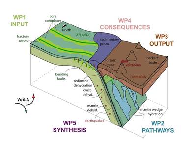
Although volatile cycling is recognised as an important process at subduction zones, questions remain with regards to: (1) the quantity of volatiles being delivered before subduction; (2) how much is released during subduction and enter lithosphere, hydrosphere and atmosphere; (3) how much goes down into the deep mantle; (4) the fluid pathway through subduction zone; (5) the effect of volatiles on faulting behaviour at various depths in subduction zones.
One specific place that interests geoscientists is the Lesser Antilles subduction zone. Here, the Atlantic lithosphere formed at the slow-spreading mid-Atlantic ridge subducts under the Caribbean Plate - potentially bringing more water down than counterparts at Pacific subduction zones. To better understand the volatile recycling at the Lesser Antilles, the UK Natural Environment Research Council funded a large multidisciplinary consortium project (VOiLA) with £3.2m. In 2016, a network of Ocean Bottom Seismometers (OBS) is installed offshore the Caribbean islands. These sensitive instruments sat on seafloor for 14 months and recorded tiny movements of the Earth when seismic waves pass. I take advantage of seismic recordings (e.g. P- and S-wave travel times) of local earthquakes to image the subsurface structure and investigate where the fluid may reside and move. Additionally, the seismic data provides rare opportunities to investigate the local seismicity, which is closely linked to seismic structure and properties.
The project involves scientists with various expertise in seismology, geology, geochemistry and geodynamics from multiple institutions around the UK (e.g. Imperial, U. Southampton, U. Bristol, U. Durham, U. Leeds, U. Liverpool).
On the seismology part of the project, collabrators include: Prof Andreas Rietbrock (Liverpool), Prof Jenny Collier (Imperial), Dr Saskia Goes (Imperial), Mr Robert Allen (Imperial), Dr Richard Davy (Imperial), Dr Catherine Rychert (Southampton), Dr Nick Harmon (Southampton), Prof Tim Penstock (Southampton), Dr Stephen Hicks (Southampton), Mr Ben Chichester (Southampton).
Relevant publications:
- Garth, T., Bie, L. et al., Lesser Antilles Wadati-Benioff zone thickness variations controlled by plate hydration, in revision.
